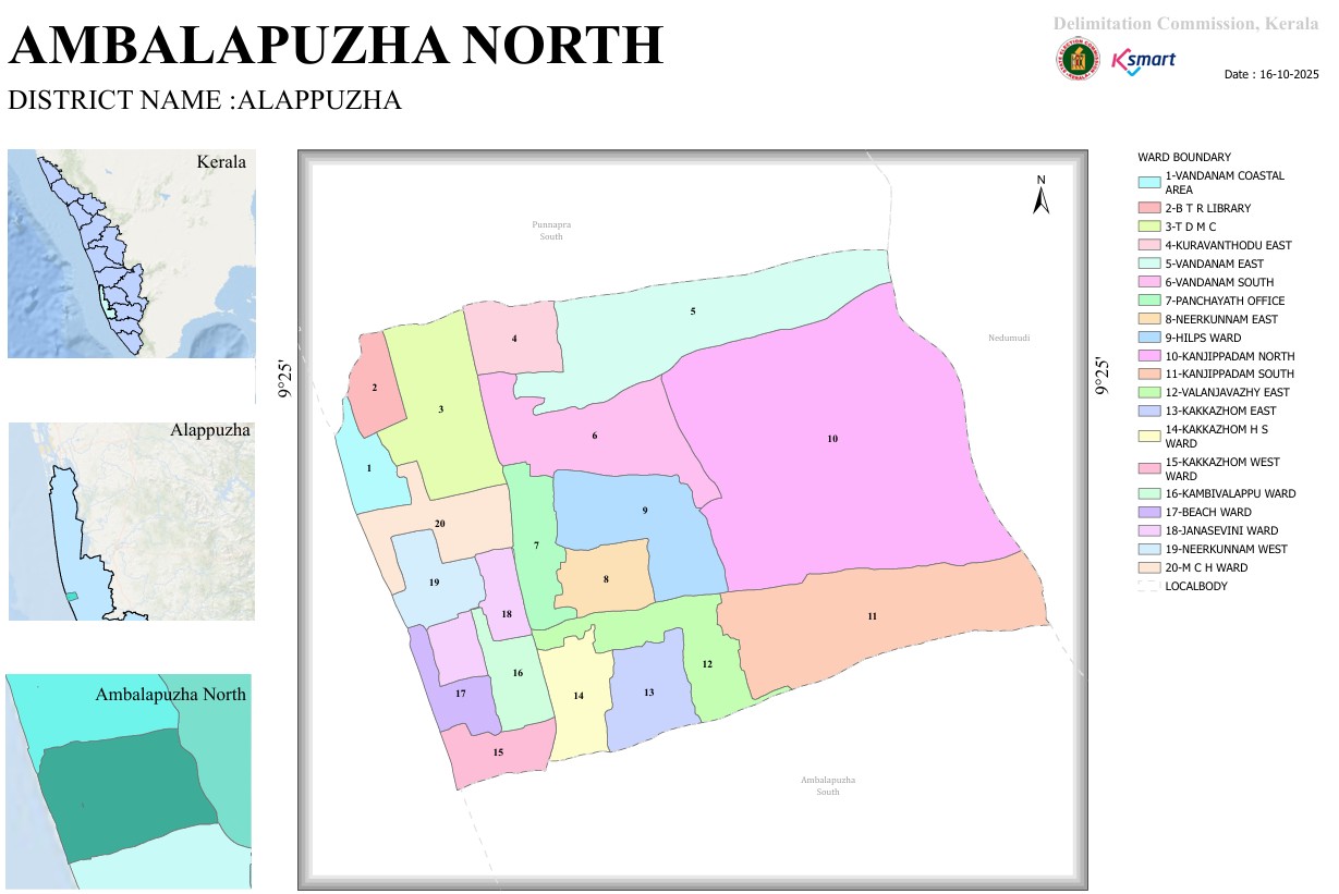

Map
Ward Division Report – Ambalappuzha North Grama Panchayat
1. Introduction
This report is prepared based on the ward division map of the Ambalappuzha North region. Ambalappuzha North is an important local self-government unit in the Alappuzha district. The map shows that the area is divided into 20 wards.
2. Basic Information
- Region: Ambalappuzha North
- District: Alappuzha
- State: Kerala
- Number of Wards: 20
- Map Date: 16-10-2025
- Prepared by: Delimitation Commission, Kerala
3. List of Wards
| Ward No. | Ward Name |
|---|---|
| 1 | Vandanam Coastal Area |
| 2 | P. T. Library |
| 3 | T. D. M. C |
| 4 | Kuravanthodu East |
| 5 | Vandanam East |
| 6 | Vandanam South |
| 7 | Panchayat Office |
| 8 | Neerkunnam East |
| 9 | H.P.L.S Ward |
| 10 | Kanjippadam North |
| 11 | Kanjippadam South |
| 12 | Valanjavazhi East |
| 13 | Kakkazham East |
| 14 | Kakkazham High School Ward |
| 15 | Kakkazham West Ward |
| 16 | Kampivalappu Ward |
| 17 | Beach Ward |
| 18 | Janasevini Ward |
| 19 | Neerkunnam West |
| 20 | M.C.H Ward |
4. Geographical Observations
- Ward 10 (Kanjippadam North) is one of the largest wards in the map.
- Wards 1 to 6 are located in the north-western region of the area.
- Wards 12 to 15 are spread across the southern boundary regions.
- Ward 7 (Panchayat Office Ward) is located centrally and is likely an administratively important area.
- Wards 16, 17, 18, 19, and 20 are smaller regions arranged in the west-southern side.
5. Boundaries
- North: Punnapra South region
- East: Nedumudi region
- South: Ambalappuzha South region
- West: Coastal area
6. Conclusion
Ambalappuzha North is a local self-government unit divided into 20 wards. The ward division appears to be based on population, geographical features, and administrative convenience. This structure helps ensure efficient governance and supports development activities within the local self-government system.